Hamilton’s Hiking Trails: Exploring Harbour Waterfront, Hermitage, and Chedoke Radial Trails
Check out our video, in which we explore the Hamilton Harbour Waterfront Trail, the Hermitage Trail, and the Chedoke Radial Trail!
Hamilton is known for its stunning landscapes, and there’s no better way to explore them than by hitting the trails!
Whether you’re seeking waterfront views, rich history, or breathtaking natural beauty, Hamilton’s diverse hiking trails offer something for everyone, and in our video, we explore 3 hiking trails that will give you a taste of it all.
Where is Hamilton?
Hamilton, Ontario is a vibrant city about an hour’s drive from Toronto. You can also reach it by GO Train from many different locations, so it makes for a perfect day trip.
Unfortunately, not many people know about the many beautiful hiking trails in the community. That’s why at 360Hamilton, we’re on a mission to ensure everyone can find and access Hamilton’s hiking trails, so we’ve made this informative blog post to help you make the most out of your hike.
We will also explore 3 of Hamilton’s most popular hiking spots – the Hamilton Harbour Waterfront Trail, the Hermitage Trail, and the Chedoke Radial Trail.
From parking tips to must-see attractions, we’ve got everything you need to plan your next outdoor adventure! So, let’s get to it.

1. Hamilton Harbour Waterfront Trail
Access Points:
Bayfront Park, 200 Harbour Front Drive, Hamilton
Pier 4 Park, 64 Leander Drive, Hamilton
This entire 7.5 km trail runs along the Hamilton Harbour from Princess Point (Cootes Paradise) through Bayfront Park, Pier 4 Park, the Discovery Centre and on to HMCS Haida, but in our video, we discuss the small section of the trail that runs from Bayfront to Pier 4 Park, since both places offer free parking and stunning views of the landscape.


Terrain:
The trail offers an easy, flat terrain perfect for walkers, runners, and cyclists. The paved path makes it accessible to people of all ages and abilities, including wheelchairs or strollers.
Length and Time:
The entire trail is roughly 7.5 kilometers and takes roughly 1.5 to 2 hours to complete, depending on your pace. Past Bayfront Park, the trail is known as part of the Great Lakes Waterfront Trail “HamBur Loop.” It’s also known as Desjardins Trail as it passes through the Desjardins Canal.
The Hamilton Harbour Waterfront Trails runs from Pier 7 to the east, through Bayfront Park, and ends at Princess Point. At the Desjardins Canal, there is also a staircase with a cycling trough that connects the trail to York Boulevard and Dundurn Castle.
Pay attention to how long you walk, as you will need to backtrack down the pavement and although the trail offers some shade, it’s quite open and exposed to the sun.
Parking:
Free parking is available at Bayfront Park and Pier 4 Park, both of which are great starting points for the hike.
Bayfront Park - 200 Harbour Front Dr, Hamilton, ON L8L 1C8
Pier 4 Park - 64 Leander Dr, Hamilton, ON L8L 1N6
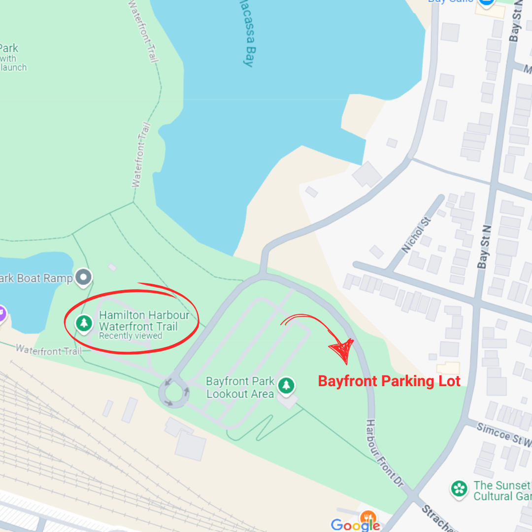
“Bayfront Parking Lot”

“Pier 4 Parking Lot”
Admission Fees:
There are no fees to use this trail.
Hours of Operation:
The Hamilton Harbour Waterfront Trail is open year-round and accessible 24/7.
Attractions:
Stunning Waterfront Views: Enjoy expansive views of the Hamilton Harbour as you make your way along the water’s edge.
Public Art and Sculptures: Keep an eye out for artistic installations along the trail, adding an extra element of creativity to your walk.
Pier 4 Park: Features a fun nautical-themed playground and a restored tugboat that’s great for families.
Restaurants and Cafes: At Pier 8, you can stop for a bite at one of the local eateries or grab a coffee by the water.
2. Hermitage Trail
Location:
621 Sulphur Springs Road, Dundas, ON
Located in Ancaster’s Dundas Valley Conservation Area, this trail offers a walk through both natural beauty and historical intrigue.


Terrain:
The Hermitage Trail features moderate terrain with some gradual inclines, making it slightly more challenging than a flat paved path. The trail is well-marked and cuts through a lush, forested area with beautiful views. There are many side trails that break off from the main loop trail, so it’s quite easy to get lost or to walk for a long time and lose track of where you are.
Pay attention to where you parked, what trail you’re on, and how long/far you’ve walked (in case you decide to backtrack as opposed to doing the entire loop). My suggestion is that you print out a trail map prior to going, and keep it with you on your hike so you can refer to the landmarks or trail signage for help if you get disoriented. You can find a printable trail map here since the trail map holders are often empty at the actual trailhead itself.
Use a timer on your phone to keep track of how long you’ve walked for, so you know how long you have to backtrack to get back to your car.

Length and Time:
The full Hermitage Trail (also known as the ‘main loop’) is 3.4 kilometers and takes about 1 to 1.5 hours to complete.
Parking:
621 Sulphur Springs Road, Dundas, ON
Parking is available at the Dundas Valley Conservation Area at the Hermitage Gatehouse lot on Sulphur Springs Road. Parking costs $11 per vehicle, but the fee also grants access to other areas within the conservation area.
*Note that there are many other parking lots to choose from, but this one puts you right beside the waterfall and a short distance from the Hermitage ruins.
Admission Fees:
There is a general admission fee for the Dundas Valley Conservation Area, which is roughly $11 per vehicle.
Hours of Operation:
The trail is open year-round, with hours generally from 8:00 AM to sunset. During winter months, trails are accessible but may be icy or snowy, so come prepared.
Attractions:
The Hermitage Ruins: One of the highlights of this trail is the historic Hermitage Ruins, a crumbling stone mansion dating back to the 1800s. The ruins are surrounded by local legends and offer a unique glimpse into the area's past.
Dundas Valley Views: As you hike, you'll pass through the gorgeous Dundas Valley, with its rolling hills, forest canopies, and an abundance of wildlife.
Waterfall: The nearby Hermitage Cascade is just a short walk away from the Hermitage Gatehouse parking lot off Sulpher Springs Rd, offering a glimpse of one of Hamilton’s many stunning waterfalls (even if it’s just a little one).
Sulpher Springs: You’ll know when you are getting close to Sulpher Springs because you’ll begin to smell sulphur in the air. This basically smells like rotten eggs. Sulpher Springs is the same spring that fed the Sulphur Springs Hotel's mineral spa in the 1800's. The waters were considered to have curative properties and hence the Hotel was a popular summer destination. The Hotel closed in 1910 due to two fires, however.
3. Chedoke Radial Trail
Access Points:
Scenic Drive - 1180 Scenic Dr, Hamilton, ON
Chedoke Golf Course - 563 Aberdeen Avenue
Running from Scenic Dr. to the Chedoke Gold Course on Aberdeen Ave., the Chedoke Radial Trail is a pedestrian and bicycle pathway developed on the former right of way of the Brantford and Hamilton Electric Railway.
It is part of the Bruce Trail and traverses the Niagara Escarpment, offering stunning views of the landscape AND a few more of Hamilton’s beautiful waterfalls.


Terrain:
The Chedoke Radial Trail is a gravel and dirt path that is well-maintained, with sections that are relatively flat and other sections that feature steep inclines.
Length and Time:
The Chedoke Radial trail is 2.7 km long (one-way), and most people complete the entire trail (there and back) in just over 2 hours.

Parking:
Scenic Drive Parking Lot - 1180 Scenic Dr, Hamilton, ON
Chedoke Golf Course - 563 Aberdeen Ave., Hamilton, ON
Free parking is available at both the Scenic Drive parking lot and the Chedoke Golf Course parking lot on Aberdeen Avenue. Both parking lots are close to the trailhead.
Admission Fees:
The Chedoke Radial Trail is free to access.
Hours of Operation:
The Chedoke Radial Trail is only open from May to November. The trail is closed from December to April due to the steep cliffs and unsafe conditions.
Attractions:
Waterfalls: This trail offers views of 3 waterfalls:
Lower Princess Falls (can be seen within a few minutes of your hike, if starting at the Scenic Drive parking lot)
Mountview Falls (depending on the time of year, this one may be hard to see due to low water flow)
Lower Westcliffe/Cliffview Falls (this one is right beside the Chedoke Golf Course parking lot)
*Note that some of Hamilton’s waterfalls are located on private property, so you should ensure that you are not trespassing when visiting these places. A best practice is to stay on marked paths (like the blue markers you see on the Bruce Trail) to avoid any hefty trespassing fines (which can start at $10,000 in some cases).
Escarpment Views: As part of the Niagara Escarpment, this trail provides sweeping views of Hamilton and the surrounding landscape.
Hamilton Has It All, Whether You’re Craving a Scenic or Historic Route
So, whether you're craving a peaceful walk by the water, a hike through historic ruins, or an adventure with spectacular waterfalls, Hamilton has it all.
Each of these trails offers something unique, from the urban charm of the Hamilton Harbour Waterfront Trail to the natural beauty and historical intrigue of the Hermitage and Chedoke Radial Trails. Best of all, each trail is accessible year-round, providing endless opportunities to explore the city’s outdoor wonders.
So, grab your hiking shoes (or boots) and get ready to uncover the best of Hamilton’s trails!

At 360Hamilton, we’re on a mission to change the way people connect to the information they need. That's why we’re actively creating content like this video about Hamilton’s hiking trails, and our blog post, which will help you get to know the wonderful city of Hamilton.
But that’s not all we've been up to. We’re also building online platforms that will enable you to provide a one-stop shop in support of your own community, no matter where you are.
Stay tuned for what’s ahead at www.360hamilton.ca. Soon, you’ll be able to combine innovative tools from videos, blog posts, news articles, online stores, collaboration, and more - all in ONE convenient location.